
Introduction:

Integrating artificial intelligence in remote sensing and Earth observation has opened new possibilities in analyzing satellite imagery and environmental change detection. AI can now detect and monitor global forests’ deforestation alterations more effectively than before, thus assisting in monitoring and curbing illegal logging activities. In addition, AI helps climate change studies by looking at how fast glaciers are melting and retreating, providing helpful information for climatic models. The use of AI in recognizing and locating the sources of pollution in combination with evaluating the weather conditions enhances air quality monitoring. Hardware improvements, such as advanced satellite sensors and drones, have made AI more effective. It unifies environmental changes by utilizing different sources of data. In addition, cloud-based systems facilitate the rapid and effective processing of vast volumes of information. These improvements make AI an essential tool for remote sensing and Earth observation.
Recent advancements in AI for satellite imagery analysis
AI in Environmental Monitoring:
Using AI, along with satellite systems, is pertinent to measuring the extent of forest cover changes to keep track of tree loss and growth. The advanced algorithms can recognize forest removal trends and detect poaching cases in real-time, enabling the relevant bodies to act promptly on those practices. Moreover, AI analysis has measures in place to assess the progress of the reforestation activities by monitoring the new tree growth and its health so that the rehabilitative endeavors are not derailed.
The application of artificial intelligence is also paramount in managing wildfires, more so in the areas of detection and prediction. Using image data from satellites, for instance, it is possible to apply artificial intelligence to predict, even before possible breakouts, situations of dry vegetation coupled with high temperatures that could cause a wildfire. This predictive aspect of AI helps carry out mass relocations before wildfires and protects people and property from damage. Such a technology further facilitates the assessment of the impact of wildfires by providing the necessary graphical representation of the sites destroyed by wildfires and estimating the level of damage that arose from the wildfires in those sites.
The application of artificial intelligence is also paramount in managing wildfires, more so in the areas of detection and prediction. Using image data from satellites, for instance, it is possible to apply artificial intelligence to predict, even before possible breakouts, situations of dry vegetation coupled with high temperatures that could cause a wildfire. This predictive aspect of AI helps carry out mass relocations before wildfires and protects people and property from damage. Such a technology further facilitates the assessment of the impact of wildfires by providing the necessary graphical representation of the sites destroyed by wildfires and estimating the level of damage that arose from the wildfires in those sites.
AI observes water bodies like lakes, rivers, and reservoirs. Satellite images are used to assess water levels and changes over time in proportionate flows, which is valuable information for understanding the occurrence of droughts or floods. This prediction system informs the management of water resources, helps anticipate flood outbursts to mitigate the effects, and assists in various protective measures for both people and nature.
Artificial intelligence can study ocean temperature, salinity, and ocean surface currents through satellite network operation, which helps to determine the state of the ocean. This knowledge helps analyze the ocean ecosystem and the changes brought by global warming. AI also assists researchers in studying biodiversity and measuring anthropogenic pressures. This is particularly useful in implementing marine protection because many reasons for it require such statistics in the first place. The speed and accuracy in processing such a vast amount of information make monitoring physical and chemical parameters of freshwater and marine ecosystems without using artificial intelligence inconceivable.
Agricultural Applications:
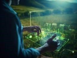
Thanks to AI, agriculture has witnessed tremendous advancement, especially in monitoring crop health and precision farming. Thanks to the analysis of satellite images, it is easy to assess the health of the crops and the yields, as well as identify any signs of disease and other threats within a very short time. This enables the farmers to respond quickly, thus minimizing crop damage and improving the quality of the products. It can even detect slight differences in the crops, which may point out an emerging problem, thus enabling farmers to solve problems more timely and focused. In precision agriculture, AI interventions are accompanied by recommendations on implementing a particular practice to achieve maximum benefits. Such techniques are based on AI that assesses temperature, soil moisture, climatic conditions, and the growth stage of a given crop to advise on the best allocation of inputs. This brings about improved production, reduced wastage, and environmental friendliness. For instance, AI could suggest the specific quantity of water and nutrients needed in a particular field zone so that the crops are given what is required and not more, thus saving on extreme resource wastes. AI is also helpful in mapping the most appropriate planting and harvest periods, enhancing farm operation efficiency by reducing rigidity in operation despite climatic variations.
Climate Change and Atmospheric Studies:
Wildlife Conservation:
Urban Planning and Development:
What are the challenges of using AI in environmental monitoring?
Case Studies and Real-world Applications

Follow Us on
Scholarship
Women in Data Science
Veterans GI Bill
Employer Tution Assistance
Corporate Training Discount
Our Office
Copyright © 2025
Created with